CC attribution: Public Domain. NASA via pingnews on flickr.
After all that “Ike Badness” last year I’m not sure I am emotionally ready for this again. However we have really improved our processes at home and work due to “Lessons Learned” exercises and our business impact and business continuity plans are sharpened and more refined than ever before.
With that in mind, I’ve decided to go back and update my GSD Hurricane Tracking Links – 2008 post
Bookmark ‘em all! (Or al least this post!)
Gulf Coast Watch List
So here are the hurricane links I am watching at home and work, to track the impending winds. Listed in order of my personal preference…

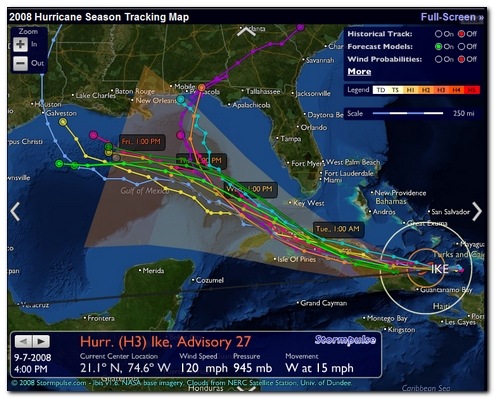
- Stormpulse / Hurricane tracking, mapping - If you like dark-themed, special-op center techno-sites, this is the one for you. The site has a lot of information and can be customized in extra data inclusions on the chart. What really makes this one cool is that it has a “Full-Screen” mode that displays as much detail as you want for the storm-track on your monitor. It provides a standard storm-track model, but you can select to include a bevy of additional forecast models if you want to really psych yourself out. Loaded up in Google Chrome or Chromium coupled with a nice dark Google Chrome Theme it really stands out projected on the wall of the incident command center.
- SciGuy Blog – Chon.com’s Eric Berger - Eric has been providing outstanding details, commentary, live chat-sessions, and analysis of all science and prognostication tropical. Highly recommended as a filter of reason and temperance in a media-market filled with over-hype, smashing graphics, and fear-factor extremes. Besides that, you can count on Eric to provide great meteorological linkage to excellent source material like this GFS global model or this the European model. It’s a must-follow/must-RSS feed blog for all Texas Gulf Coast residents. Period. (see also Jeff Masters’ Wunder Blog : Weather Underground).
- IBISEYE.com -- Your Atlantic Hurricane Season Tracking Map Source – An awesome site that mashes up tracking data on hurricanes and points of interest, along with Google Maps. Heavy on the JavaScript but makes up for it in pure visual delight. Easy enough even the “old-folks” can understand. Not only are hurricanes and projected paths displayed, but also counties are added as they fall under various storm watches and warnings. Zoom in/out for more detail.
- Tropical Atlantic: NHC Model Data for Tropical Storms – TropicalAtlantic beta – For folks who need to have more than one storm-track model presented, this is like going from riding a pony to driving cattle from North Dakota to the Fort Worth Stockyards. Look at the top of the page to select any current storms. Then when the Google Map mash-up launches, you can pick from 32 “Early” models and 38 “Late” model storm track models. Plot one or plot them all! Awesome! Additional NOAA summary of storm-track models. Also, Tropical Atlantic: Information About Atlantic Hurricanes – main-page.
- Hurricane and Storm Tracking - Terrapin's site remains a dear favorite. It is lean and simple and allows for quick location of information without lots of graphic overkill. The storm-track plots come in two flavors, a simple historical and future projection track that is static as well as a java-based animated one. Loads fast and updated as new forecasts are posted.
- National Hurricane Center - This website maintained by the National Weather Service is my number two choice. Lots more linkage on the sidebar for hurricane related topics and preparations. The main page has links to a number of graphics and advisories.
- (NHC's) Atlantic Graphical Tropical Weather Outlook - A "beta" sub-page of the site listed above. This is pretty cool. Any current tropical systems are overlayed on a satellite image with an icon. Hovering over the icon pulls up a quick update view. Clicking on the update popup then takes you to the system's detailed page.
- Moreweather.com -- Tropical Atlantic Weather Page - T-Storm Terry Faber has created a great hurricane system page here. Not only does it have lots of links to any active systems, but it also contains links to radar and satellite images, many in great details and high resolution. The hurricane tracking maps and projections are there, of course. T-Storm Terry also provides links to other sources of information as well as historical data on previous storm systems.
- Tropical Weather : Weather Underground - This is a fantastic site that has the widest range of linkages, maps, images, models, and everything. Just about the only thing it doesn't provide is winds blown into your face through the monitor. Which is why I put this at the bottom and not the top: there is just so much information it overwhelms.
- Oklahoma Weather Lab | Hoot - Models: GFS Model Upper-Level Wind 850mb provided us great forecast models of the high/low pressure zones and ridges leading up to Ike’s eventual landfall and really helped us understand the forces driving its path.
Local Winds
For local Houston area facts and updates, most of the local news stations have their web-sites powered up.
- Hurricane Central | Chron.com - Houston Chronicle - I generally turn to the Houston Chronicle's website for the majority of my information locally.
- Harris County Homeland Security & Emergency Management - Main page links to the new Evacuation maps, Contraflow routes, etc.
- Fox News 26 - Hurricane Toolbox - Lots of links and helpful tips
- abc13.com: Gulf Coast Hurricane Guide - Again lots of links and preparedness tips.
- StormWatch, KPRC Local 2 Click2Houston - News channel 2's public information page.
- HURRICANE CENTRAL from 11 News KHOU.com - One more local news site's tropics page.
Even More Weather
I have found these additional links pretty cool:
- e-WALL : PSU ELECTRONIC MAP WALL – Too Much Information! But still cool.
- TROPICAL ATLANTIC e-WALL – I’m no meteorologist, but I can play one at work and home!
- Real Time Tropical Cyclone Research Page– University of Central Florida. Lots of additional links.
Road Kill
- Houston TranStar Real-Time Traffic Map,
- Houston TranStar Cameras, and
- Houston TranStar Incidents and Road Closures.
You just don’t want to be caught off guard when one of these comes knocking at your door.

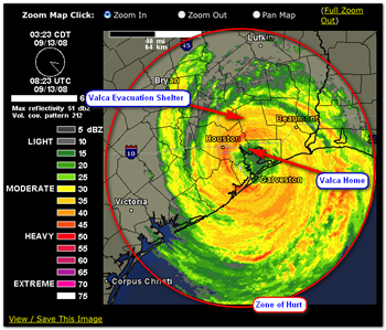
Ike radar image captured by Jim Thompson of jimthompson.org
--Claus

2 comments:
I hope the storms stay away from FL.
You might also want to try the direct-feed satellite loops and stills that the US NWS hosts at http://www.ssd.noaa.gov/PS/TROP/trop-atl.html
One of the "Advisories" that the NHC provides that I find especially useful is the "Discussion" which is basically an executive summary of how the current forecast advisory was developed. The divergence of the tracking and intensity models is discussed as well as any subjective weightings that have been applied by the forecaster.
Post a Comment