Showing posts with label hurricanes. Show all posts

Sunday, June 14, 2015

GSD Hurricane Tracking Links – 2015 edition

nmev1i1k.h2uCC attribution: by "An Honorable German" (Charles McCain) on flickr.

The last several years have been really quiet on the tropical storm front here on the Texas Gulf coast. So I ended up skipping a GSD Hurricane Tracking Links page update in 2013 & 2014.

And like in 2012, we again begin to turn our attention out into the Gulf waters and begin our monitoring of tropical development Invest 91L.  So here we go just like back in 2012’s drill. Fire up the engines, check and re-check the GSD hurricane linkages, and get this post into the skies.

Refresh your bookmarks!

Gulf Coast Watch List

Here is the updated list of hurricane links I am watching at home and work. Not a whole lot of changes this year, but some URL’s have changed and some sites have gone dark. 

Listed in order of my current personal preference…

Google Earth – Google Earth has taken 1st place in the list this season. (You may not be aware but you can now get the “Google Earth Pro” for free!) But to harness the power of tropical storm tracking in Google Earth, you must first install the wicked-awesome Google Earth Network Link For Entire Basin (direct download link) KMZ files provided by the Tropical Atlantic website and you are ready for some major storm-path modeling. When a storm comes, you can also go to the specific storm page and download/use the KMZ files for just that storm as well. Once you download the file, be sure to save it “permanently” in your Google Earth preferences so it will be available and “updatable” with the latest data when needed. Lay in some of the FEMA flood hazard layers for more usefulness. Finally, supplement it some more with tools from these Google Earth Blog links: Storm Tracking With Google Earth & More tools to help track Hurricane Irene that has a link to the Live Hurricane Hunter Missions.

WunderMap® - Interactive Weather Map and Radar via the Weather Underground. It still surprises me that so many of my coworkers, family and friends still don’t know about this site. The radar data seems very close to “real-time” where other radar sites have a 5-10 min lag time. The main page shows you your area weather typically with weather stations and radar showing. However if you go to the side bar, you can add a ton of more weather data and projections. For my purposes in this context, I generally remove the “weather stations” overlay, add the “Severe Weather” overlay, sometimes the “Tornado” overlay also. Then you can add the “Tropical” layer and check (as needed) the “Hurricanes”, “Sea Surface Temps” overlay, the “Storm Surge” overlay, and (hopefully not required) the “Evacuations Routes” overlay. If you aren’t careful you can get a big overload of stuff on your screen!   Each of those layers has it’s own settings to fiddle with. For the “Hurricane” overlay, you can look at the wind radius, the cone of uncertainty, the forecast, the past track observations, hurricane hunter observations, and computer model tracks. THEN, you can also go down to the “Model Data” layer and pick different models, map-types to your heart’s desire, and model-runs. Finally, you can run a forecast projection loop. How awesome is this!

SciGuy “Weather” & SciGuy “Hurricanes” category blogs - Chon.com’s Eric Berger - It’s probably not a good idea to attempt to interpret all these charts and data on your own to make life-impacting decisions as a hurricane bears down on you. Fortunately, Eric continues to faithfully provide Houstonians and neighbors beyond his outstanding details, no-nonsense, no hyperbole commentary, live chat-sessions, and analysis of all science and prognostication tropical. Highly recommended as a filter of reason and temperance in a media-market filled with over-hype, smashing graphics, and fear-factor extremes. Besides that, you can count on Eric to provide great meteorological linkage to excellent source material like this GFS global model or this the European model. It’s a must-follow/must-RSS feed blog for all Texas Gulf Coast residents. Period. (see also Jeff Masters’ Wunder Blog : Weather Underground).

Moreweather.com -- Tropical Atlantic Weather Page - T-Storm Terry Faber has created a great hurricane system page here. Not only does it have lots of links to any active systems, but it also contains links to radar and satellite images, many in great details and high resolution. The hurricane tracking maps and projections are there, of course. T-Storm Terry also provides links to other sources of information as well as historical data on previous storm systems.

Tropical Atlantic: NHC Model Data for Tropical Storms – TropicalAtlantic – For folks who need to have more than one storm-track model.  Look at the top of the page to select any current storms.  Then you can select either the “in-browser” Google Maps mash-up or the Google Earth TMZ builds.  Additional NOAA summary of storm-track models. Also, Tropical Atlantic: Information About Atlantic Hurricanes – main-page. 

National Hurricane Center - Website maintained by the National Weather Service. Lots more linkage on the sidebar for hurricane related topics and preparations. The main page has links to a number of graphics and advisories.

(NHC's) Atlantic Graphical Tropical Weather Outlook - A sub-page of the site listed above. This is pretty cool. Any current tropical systems are overlayed on a satellite image with an icon. Hovering over the icon pulls up a quick update view. Clicking on the update popup then takes you to the system's detailed page.

Tropical Weather : Weather Underground - This is a fantastic site that has the widest range of linkages, maps, images, models, and everything. Just about the only thing it doesn't provide is winds blown into your face through the monitor. Which is why I put this at the bottom and not the top: there is just so much information it overwhelms.

Tropical Cyclone Guidance Project | Real-Time Guidance - NCAR Research Applications Laboratory - “The real-time guidance system generates an individual page for each active storm in the North Atlantic, Northeast Pacific, and North Central Pacific basins. Each individual storm page features the latest plots of model guidance and intensity forecast aids for that storm, as well as other diagnostic and observational information.” Drill down into great plot track guidance models.

Oklahoma Weather Lab | Hoot - Models: GFS Model Upper-Level Wind 850mb provided us great forecast models of the high/low pressure zones and ridges leading up to Ike’s eventual landfall and really helped us understand the forces driving its path.

WeatherBELL Models - Amazing collection of high-quality weather models and data. Until you get focused, you can easily get lost for hours in the charts, visual model animated “loops”. My head is spinning and I’m afraid I will start to be dreaming in whirls of colors! There are both subscription and free map data on the page. Look for the links under “freely available” such as this “HRRR 3-km Simulated Radar” 15-hr Animated GIF loop projection.

Skeetobite Weather - Charts and data site. Good stuff here with nice clean graphs, graphs, and data linkage.

Hurricane and Storm Tracking - Terrapin's site remains a dear favorite. It is lean and simple and allows for quick location of information without lots of graphic overkill. The storm-track plots come in two flavors, a simple historical and future projection track that is static as well as a java-based animated one. Loads fast and updated as new forecasts are posted.

Atlantic and Caribbean Tropical Satellite Imagery - Satellite Services Division / Office of Satellite Data Processing and Distribution and Gulf of Mexico Imagery - Satellite Services Division / Office of Satellite Data Processing and Distribution from the NOAA.  Special thanks to GSD frequent commentator “Bozo” for sharing this great source of satellite images from NOAA with me.

Experimental forecast Tropical Cyclone Genesis Potential Fields - Department of Earth, Ocean, and Atmospheric Science, Florida State University - Great supplemental animated and static image data on a lot of key tropical weather-related information points.

National Weather Service - another top-level landing point to drill down deeper into forecast maps, radar imagery, etc.

National Weather Service Doppler Radar Images - link to various NWS/DoD Radar sites. Select your focus then add additional details and information via the bottom control bar as well as run loops from the left control bar.

Tropical Cyclone Heat Potential Page: Global Fields - Select your basin map field on the left (such as the Gulf of Mexico). Put very simply, understanding what the water temperatures are and combining them with storm-track information might help one forecast potential intensification/intensity of a tropical storm. Of course lots of other factors play into the mix as well…

Gulf of Mexico AVN Color Imagery – NOAA Satellite Services Division - nice radar loop imagery with options to add additional data markers to the base image. Provided by the NOAA Satellite and Information Service/NESDIS) (AVN=Aviation)

Satellite Analysis Branch Tropical Homepage – NOAA Satellite Products and Services Division – Stuff at the top but scroll down and get some additional product data views. I like the MTCSWA to show mid-level wind analysis.

Gulf of Mexico Visible Imagery - Satellite Services Division - nice visible satellite loop imagery with options to add additional data markers to the base image. Provided by the NOAA Satellite and Information Service/NESDIS)

Latest Satellite Imagery - NOAA site that has links to a large number of additional satellite imagery. Neat stuff, for example this GOES Floater Imagery with Java, Flash, and GIF loops

READY - Forecast Model Animations – NOAA forecast model animation loops. Good place to grab some projection GIFS for forecasting.

NEXSAT, NRL/JPSS Next Generation Weather Satellite Demonstration Project - Super-duper cool satellite images and loops. Again drill in to get to the NEXSAT area of interest (such as the Gulf of Mexico), then use the controls above and to the left as needed to tweak your views.

NCEP Central Operations - National Weather Service link - Pick the option you want under the topics or side bar and drill down.

Weather & Climate Data - COLA - Additional links for current conditional analysis, forecasts, climate outlooks and hurricane intensity models.

Galveston Bay Operational Forecast System (NGOFS-Galveston Bay) - NOAA Tides and Currents for the Galveston Bay area - super neat tidal and water level information useful for those who dwell on the rim of Galveston Bay. Also reports wind and current data with animated loop views available.

Northern Gulf of Mexico Operational Forecast System (NGOFS) - NOAA Tides and Currents for the wider upper Gulf of Mexico costal areas.

Texas Storm Surge Models - Wunderground - For additional storm surge inundation maps for US coastlines, see this page Storm surge imagery for the U.S. coast | Weather Underground

U.S. NEXRAD and TDWR Radar Stations - Wunderground - I’m linking to the main map from which specific radar stations can be chosen depending on your area of attention; though the Houston Hobby and Houston-Galveston interest me the most. The radar images have lots of cool tweaks you can perform on them so spend some time getting to know them!

Stormpulse / Hurricane tracking, mapping -Stormpulse is now a subscription-based access site . They remain providing a “live” mini-display view on their home page that contains a light amount of the imagery and tracking projections that we all used to love. If you are desperate and pine for the days of Stormpulse of old, then hop over there and just zoom up your browser window display size to your heart’s content.

Local Winds

For local Houston area facts and updates, most of the local news stations have their web-sites powered up.

Even More Weather

I have found these additional links pretty cool:

Road Kill

Again as it bears repeating, you just don’t want to be caught off guard when one of these comes knocking

--Claus V.

Sunday, October 28, 2012

For-Sec & Utility Jumble Linkfest

Wordle_2012-10-28_10-49-54

The short weekend is done. The “Sandy Watch” is on for what could be -- for our northeastern friends -- a storm event to be remembered for many years to come. So comes a pile of security/forensic and utility-minded links spill out below for the curious and information hungry.

Forensics and Security

Girl, Unallocated: Be Very Quiet... I'm Tracking Emails Through Headers - Girl, Unallocated Blog. The Girl has a great post looking at email headers and their bits and perils. One gem is a report (PDF) from Stroz Friedberg and a particular focus on email headers. The report as a whole is a great read and again provides a lesson in technical report writing and presentation as well as some forensics pushback on anti-forensics techniques. At 102 pages, it isn’t a brief, but well worth the time to download and study.

The Girl’s post reminded me of another great publicly-available report that addressed emails in a forensic investigation.  In my GSD post Interesting Malware in Email Attempt - URL Scanner Links, I wrote the following bits at the end:

A recent Digital Forensics Case Leads post has mention of a super-fantastic investigation/forensic report involving anonymous emails. This is must-read material, not just in terms of the investigative methodology but also the way the report was composed and presented. Very clearly done!  I’m keeping a saved copy of the report for future reference; both technically and as a report template. From the post via the link above:

“University of Illinois recently released a detailed investigation report (PDF) regarding anonymous emails allegedly sent by its Chief of Staff to the University's Senates Conference. The report is an interesting read, and also serves as a potentially useful model for those looking for report samples and templates.”

How a Google Headhunter's E-Mail Unraveled a Massive Net Security Hole - Threat Level @ Wired.com.  I almost overlooked Kim Zetter’s post on how Mathematician Zach Harris -- as an exercise -- discovered a flaw in some providers user of a weak DKIM key to sign emails originating from them. Fascinating and short read.

DEFT 7.2 and DEFT english manual, ready for download! DEFT Linux - Computer Forensics live cd . New DEFT version out. Last one in x32 bits. Future versions will be strictly x64 flavored.

Xplico – Xplico 1.0.1 - Xplico new version release just dropped. From the brief post:

ChangeLog:

  • nDPI integration
  • performace improved
  • FTP dissector improved
  • Added the prism dissector
  • CLI execution bug fixed
  • PCAP-over-IP SSL encryption
  • IRC dissector improved
  • File reconstruction from Fragmented Payloads improved
  • FaceBook Chat updated
  • FaceBook Message (partial)
  • HTTP without initial packets (packets lost)
  • RTP dissector improved
  • PCAP2WAV, RTP2WAV interface added

And don’t forget! Now you can update/get via apt-get! for Ubuntu 11.04 and higher.  Sweet!

sudo bash -c 'echo "deb http://repo.xplico.org/ $(lsb_release -s -c) main" >> /etc/apt/sources.list'
sudo apt-key adv --keyserver keyserver.ubuntu.com --recv-keys 791C25CE
sudo apt-get update
sudo apt-get install xplico

LastActivityView - Nirsoft brand new utility! - Use this new tool to view the latest computer activity in Windows operating system. Nir Softer has some more details on his NirBlog: New utility that shows general computer activity. Could be useful for incident response and analysis and other “quick peeks” for key system activity indicators to narrow down the search.

FileAlyzer Portable 2.0.5.57 (detailed file analyzer) Released -PortableApps.com

Hacking KeyLoggers - Open Security Research has a great post that not only identified a USB keylogging device, but takes it to the next level in hacking it to determine the impact of the device and when it might have been dropped. Clever stuff.

Attacking TrueCrypt - The H Security: News and Features. Another interesting post that almost slipped by me. Interesting by itself but also shows the benefit of using “cascaded algorithms” in TrueCrypt to thwart current attacks…for now.

Restoration of defocused and blurred images - Yuzhikov.com. This is super cool.  Vladimir Yuzhikov hasn’t just done a proof of concept for de-fuzzing blurred imaged (either out of focus or those blurred with a mathematical algorithm), no, he has actually released a free Windows app to demonstrate the possibilities. Besides images, text that is out of focus can be unblurred as well. This is very fascinating and could assist investigators facing images and other digital files with blurred faces or content. It’s not exactly easy or guaranteed to work, but it is very promising start and Vladimir notes he is continuing development and refinement. Read his work please and snag the download.

Google Drive opens backdoor to Google accounts - The H Security: News and Features . Quoting from the post, “The Windows and Mac OS X desktop clients for Google's Drive file storage and synchronisation service open a backdoor to users' Google accounts which could allow the curious to access a Drive user's email, contacts and calendar entries.”  read the post for more info. As usual it seems to be a convenience versus security trade-off again. Choose your cake wisely. I stick with using only the web interfaces and pass on the client versions of these cloud-based storages services…for now.

Virtualization

The TinyApps bloggist has been hard at work digging out great tips and techniques for importing the virtualized “Windows XP Mode” into popular virtualization software. As always, the posts are impeccable with lots of details and supporting source documentation for additional study and research.

Oracle VM VirtualBox - Version 4.2.4 just dropped…by the way. I almost missed it were it not for my RSS feed filters. See the changelog for more details.  And be sure to grab the 4.2.4 VM VirtualBox Extension Pack as well.

Miles’ posts reminded me of an earlier GSD summer post Virtual Solutions and his great post comment guiding me to getting MS’s IE VirtualPC images running in Virtual Box.

How to run Microsoft’s IE VPC images in VirtualBox
http://tumblr.jonthornton.com/post/11405634980/how-to-run-microsofts-ie-vpc-images-in-virtualbox

ievms - Automated installation of the Microsoft IE App Compat virtual machines
https://github.com/xdissent/ievms

Browser Plugin Update Time…Again.

Yes dear readers, it is “Jack and Jill” time again. Bother.

Adobe Shockwave got updated, as of this post, the newest (Windows) version of Adobe Shockwave is currently 11.6.8.638.

Adobe Flash was updated as well. Newest (Windows) version is currently 11.4.402.287.

Java also got a quick update to both build versions. Windows Java updates are available in 1.6.0_36 and 1.7.0_09.

Trying to figure out if all your browser plug-ins are current can be a super-pain for the inexperienced and geekless.

My go-to recommendation remains to pop over to Qualys BrowserCheck in each of your installed web-browsers, be it Chrome, Windows IE, or Firefox. Alas, Opera, Safari, and other browsers are not currently supported, however a check in one of the supported browsers may quite likely uncover a outdated plug in, patching it may fix the others in the process.  For a backup check, hope over next to The Secunia Online Software Inspector for a second opinion.

If you want a good all-in-one location to manually download your plugs, check out Browsers and Plugins Downloads over at FileHippo.com.

Utility and SysAdmin Finds of the Week

Defrag Tools: #13 - WinDbg - Defrag Tools @ Channel 9. New video on Sysinternals tool usage; specifically integrating Debugging Tools for Windows.

Case of the CertUtil Import Refusing The Correct Password - chentiangemalc. Great practicum post on troubleshooting a strange password error where the password was correct but not being taken.

SpeedyFox - Boost Firefox,Skype,Chrome,Thunderbird in a Single Click! - CRYSTALIDEA Software . It has been forever…like dinosaurs roaming the earth eras ago…since I last saw any post anywhere on speeding up a pokey Firefox browser by “optimizing” the JSON databases. This is a dead-simple process to improve launch-time for a well-used Firefox browser. It’s been months since I last optimized mine. When I went to run SpeedyFox, my favorite tool to do so, I wondered if there had been an updated release. My version was at least a year old.  Happily I found there was a newer version, and that it now supports optimizing Chrome-based browsers as well. It remains available as a free edition. Current version is 2.0.3 but while I was sleeping, the developers have been adding support for Skype, Chrome (including SRWare Iron and Pale Moon), Mozilla Thunderbird, and Firefox (including Epic Browser). There is a Mac version (Firefox only) also.

If you use Firefox/Chrome/Thunderbird, stop, drop and run right now!  Did I mention it supports custom paths to your browser profiles so you can optimize portable versions on your drive/disks? Sweet baby Jebus!

CR2 Converter - I shot a lot of photos for Lavie and her family last weekend with the Canon 5D Mark II.  Pops asked for copies and when I was getting ready to pass them off, I realized I had not changed the setting from “RAW” only to RAW+JPEG. So I had over 300 digital images in RAW .cr2 format that his computer cannot read and that are not really a practical format for him anyway to use. Sure, I could batch-convert them in Lightroom/Photoshop, but I really just needed to get them quickly on a CD for him.  I have more than a few RAW freeware tools for tweaking individual RAW file images but that was too time-consuming to use. Luckily, with just a bit of Google diving, I found the freeware Canon RAW Image Converter “CR2 Converter”.   It supports batch-conversion and did an acceptable job for this task. My i7 x64 8 GB RAM system chewed through converting the files in no-time.  To my eyes the resulting images were a bit lightly purple-tinted…not bad or unpleasant but definitely noticeable when compared to the RAW file. Nothing that some simple color correction can’t fix if really important. For Pops it wasn’t but YMMV.  I wouldn’t use it everyday for batch processing but for quick-n-dirty RAW .cr2 to JPEG/JPG/GIF/BMP/PNG/TIFF conversions it is a super time-saver. Tuck it away for when needed in a pinch.

Cheers and hopes and prayers for the very best across the north-east seaboard as Sandy rolls in.

--Claus V.

Saturday, August 04, 2012

GSD Hurricane Tracking Links – 2012

nmev1i1k.h2uCC attribution: by "An Honorable German" (Charles McCain) on flickr.

Looks like I skipped doing a GSD Hurricane Tracking Links page update in 2011. I guess that’s because the tropics were very quiet for us last year. That’s a Good Thing ™.

Today the Valca clan spread from Houston into the remote reaches of Louisiana now watch with interest the multiple Atlantic Basin churnings.  So it seems fitting to fire up the engines, check and re-check the 2010 GSD hurricane linkages, and get this post into the skies.

Refresh your bookmarks!  (Or at least your link to your GSD Hurricane tracking post!)

Gulf Coast Watch List

Here is the updated list of hurricane links I am watching at home and work. There have been some changes--and additions--due to business model changes at some locations. And I’ve come across a few new and worthy sites to track the impending winds.

Listed in order of my current personal preference…

IBISEYE.com -- Your Atlantic Hurricane Season Tracking Map Source – An awesome site that mashes up tracking data on hurricanes and points of interest, along with Google Maps. Heavy on the JavaScript but makes up for it in pure visual delight. Not only are hurricanes and projected paths displayed, but also counties are added as they fall under various storm watches and warnings. Zoom in/out for more detail.

Google Earth – Google Earth remains in 2nd place in the list this season only because IBISEYE provides (IMHO) the best “at-a-glance” charting of big-picture storm data. Couple that with the wicked-awesome Google Earth Network Link For Entire Basin (direct download link) KMZ files provided by the Tropical Atlantic website and you are ready for some major storm-path modeling. When a storm comes, you can also go to the specific storm page and download/use the KMZ files for just that storm as well. Once you download the file, be sure to save it “permanently” in your Google Earth preferences so it will be available and “updatable” with the latest data when needed. Lay in some of the FEMA flood hazard layers for more usefulness. Finally, supplement it some more with tools from these Google Earth Blog links: Storm Tracking With Google Earth & More tools to help track Hurricane Irene

SciGuy Blog – Chon.com’s Eric Berger - It’s probably not a good idea to attempt to interpret all these charts and data on your own to make life-impacting decisions as a hurricane bears down on you. Fortunately, Eric continues to faithfully provide Houstonians and neighbors beyond his outstanding details, commentary, live chat-sessions, and analysis of all science and prognostication tropical. Highly recommended as a filter of reason and temperance in a media-market filled with over-hype, smashing graphics, and fear-factor extremes. Besides that, you can count on Eric to provide great meteorological linkage to excellent source material like this GFS global model or this the European model. It’s a must-follow/must-RSS feed blog for all Texas Gulf Coast residents. Period. (see also Jeff Masters’ Wunder Blog : Weather Underground).

Skeetobite Weather - New (to me) charts and data site found by keeping a keen eye on Eric Berger’s hurricane posting data linkage. Good stuff here with nice clean graphs, graphs, and data linkage.

Tropical Atlantic: NHC Model Data for Tropical Storms – TropicalAtlantic – For folks who need to have more than one storm-track model.  Look at the top of the page to select any current storms.  Then you can select either the “in-browser” Google Maps mash-up or the Google Earth TMZ builds.  Additional NOAA summary of storm-track models. Also, Tropical Atlantic: Information About Atlantic Hurricanes – main-page. 

Hurricane and Storm Tracking - Terrapin's site remains a dear favorite. It is lean and simple and allows for quick location of information without lots of graphic overkill. The storm-track plots come in two flavors, a simple historical and future projection track that is static as well as a java-based animated one. Loads fast and updated as new forecasts are posted.

National Hurricane Center - Website maintained by the National Weather Service. Lots more linkage on the sidebar for hurricane related topics and preparations. The main page has links to a number of graphics and advisories.

(NHC's) Atlantic Graphical Tropical Weather Outlook - A sub-page of the site listed above. This is pretty cool. Any current tropical systems are overlayed on a satellite image with an icon. Hovering over the icon pulls up a quick update view. Clicking on the update popup then takes you to the system's detailed page.

Moreweather.com -- Tropical Atlantic Weather Page - T-Storm Terry Faber has created a great hurricane system page here. Not only does it have lots of links to any active systems, but it also contains links to radar and satellite images, many in great details and high resolution. The hurricane tracking maps and projections are there, of course. T-Storm Terry also provides links to other sources of information as well as historical data on previous storm systems.

Tropical Weather : Weather Underground - This is a fantastic site that has the widest range of linkages, maps, images, models, and everything. Just about the only thing it doesn't provide is winds blown into your face through the monitor. Which is why I put this at the bottom and not the top: there is just so much information it overwhelms.

Oklahoma Weather Lab | Hoot - Models: GFS Model Upper-Level Wind 850mb provided us great forecast models of the high/low pressure zones and ridges leading up to Ike’s eventual landfall and really helped us understand the forces driving its path.

Tropical Cyclone Guidance Project | Real-Time Guidance - NCAR Research Applications Laboratory - “The real-time guidance system generates an individual page for each active storm in the North Atlantic, Northeast Pacific, and North Central Pacific basins. Each individual storm page features the latest plots of model guidance and intensity forecast aids for that storm, as well as other diagnostic and observational information.” - added 08/10/2012 via a tip from SciGuy blog Eric Berger. Drill down into great plot track guidance models.

WeatherBELL Models - Amazing collection of high-quality weather models and data. Until you get focused, you can easily get lost for hours in the charts, visual model animated “loops”. My head is spinning and I’m afraid I will start to be dreaming in whirls of colors! - added 08/10/2012 via a tip from SciGuy blog Eric Berger.

Experimental forecast Tropical Cyclone Genesis Potential Fields - Department of Earth, Ocean, and Atmospheric Science, Florida State University - Great supplemental animated and static image data on a lot of key tropical weather-related information points. - added 08/10/2012 via a tip from SciGuy blog Eric Berger.

Atlantic and Caribbean Tropical Satellite Imagery - Satellite Services Division / Office of Satellite Data Processing and Distribution and Gulf of Mexico Imagery - Satellite Services Division / Office of Satellite Data Processing and Distribution from the NOAA.  Special thanks to GSD frequent commentator “Bozo” for sharing this great source of satellite images from NOAA with me last year.

National Weather Service - another top-level landing point to drill down deeper into forecast maps, radar imagery, etc. - added 08/25/2012

National Weather Service Doppler Radar Images - link to various NWS/DoD Radar sites. Select your focus then add additional details and information via the bottom control bar as well as run loops from the left control bar. - added 08/25/2012

Tropical Cyclone Heat Potential Page: Global Fields - Select your basin map field on the left (such as the Gulf of Mexico). Put very simply, understanding what the water temperatures are and combining them with storm-track information might help one forecast potential intensification/intensity of a tropical storm. Of course lots of other factors play into the mix as well… - added 08/25/2012

Gulf of Mexico AVN Color Imagery - Satellite Services Division - nice radar loop imagery with options to add additional data markers to the base image. Provided by the NOAA Satellite and Information Service/NESDIS) (AVN=Aviation) - added 08/25/2012

Gulf of Mexico Visible Imagery - Satellite Services Division - nice visible satellite loop imagery with options to add additional data markers to the base image. Provided by the NOAA Satellite and Information Service/NESDIS) - added 08/25/2012

Latest Satellite Imagery - NOAA site that has links to a large number of additional satellite imagery. Neat stuff. - added 08/25/2012

NEXSAT, NRL/JPSS Next Generation Weather Satellite Demonstration Project - Super-duper cool satellite images and loops. Again drill in to get to the NEXSAT area of interest (such as the Gulf of Mexico), then use the controls above and to the left as needed to tweak your views. - added 08/25/2012

NCEP Central Operations - National Weather Service link - Pick the option you want above the map, then select the type and area. Finally make one or more final option picks and you get some very helpful graphs. - added 08/25/2012

Weather & Climate Data - COLA - Additional links for current conditional analysis, forecasts, climate outlooks and hurricane intensity models. - added 08/25/2012

Galveston Bay Operational Forecast System (GBOFS) - NOAA Tides and Currents for the Galveston Bay area - super neat tidal and water level information useful for those who dwell on the rim of Galveston Bay. Also reports wind and current data with animated loop views available. - added 08/25/2012

Northern Gulf of Mexico Operational Forecast System (NGOFS) - NOAA Tides and Currents for the wider upper Gulf of Mexico costal areas. - added 08/25/2012

Texas Storm Surge Models - Wunderground - For additional storm surge inundation maps for US coastlines, see this page Storm surge imagery for the U.S. coast | Weather Underground - added 09/01/2012

U.S. NEXRAD and TDWR Radar Stations - Wunderground - I’m linking to the main map from which specific radar stations can be chosen depending on your area of attention; though the Houston Hobby and Houston-Galveston interest me the most. The radar images have lots of cool tweaks you can perform on them so spend some time getting to know them! - added 09/01/2012

Computer models - USATODAY - old but a good starting point introducing foundations to weather forecast models. - added 08/25/2012

Stormpulse / Hurricane tracking, mapping - Sadly, Stormpulse has now been diminished to the bottom of the pile. The site developers have modified their business model (you go dudes!) to now be solely subscription-based access. There are some time-limited free-trials you can access. Currently they are not offering any “consumer-level” subscription services and the basic package is probably still too pricy for all but the most crazy consumer weather-heads. All that said, they do still have a “live” mini-display view on their home page that contains a fair amount of the imagery and tracking projections that we all used to love. If you are desperate and pine for the days of Stormpulse of old, then hop over there and just zoom up your browser window display size to your heart’s content.

Local Winds

For local Houston area facts and updates, most of the local news stations have their web-sites powered up.

Even More Weather

I have found these additional links pretty cool:

Road Kill

Again as it bears repeating, you just don’t want to be caught off guard when one of these comes knocking

--Claus V.

Saturday, July 03, 2010

GSD Hurricane Tracking Links – 2010

Hurricane Gordon

CC attribution: Public Domain. NASA via pingnews on flickr.

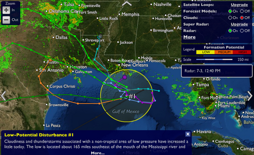
OK.  We in Houston appear to have survived being drenched by the fallout from early-season opener Alex here in 2010.  Despite making landfall in costal Mexico a bit south of Brownsville, Texas, the far-reaching bands have been bringing feeder-bands of rain for the past 3-4 days.  This Saturday is the first glint of sunshine.  Although there is currently a non-tropical area of low pressure sitting off the mouth of the “Mighty Miss” looking to slide into our area over the next few days.  Oh bother.

With predictions already coming true of a particularly active and strong 2010 hurricane season, it’s time to refresh the GSD hurricane tracking links for 2010.

Bookmark ‘em all!  (Or al least this post!)

Gulf Coast Watch List

So here are the hurricane links I am watching at home and work, to track the impending winds. Listed in order of my personal preference…

image

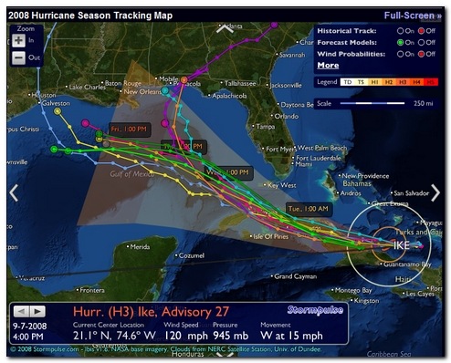
  • Stormpulse / Hurricane tracking, mapping - If you like dark-themed, special-op center techno-sites, this is the one for you. The site has a lot of information and can be customized in extra data inclusions on the chart. What really makes this one cool is that it has a “Full-Screen” mode that displays as much detail as you want for the storm-track on your monitor.  It provides a standard storm-track model, but you can select to include a bevy of additional forecast models if you want to really psych yourself out. Loaded up in Google Chrome or Chromium coupled with a nice dark Google Chrome Theme it really stands out projected on the wall of the incident command center.
  • Google Earth – What? Yep. Google Earth is now coming in to 2nd place in the list this season.  Couple that with the wicked-awesome Google Earth Network Link For Entire Basin (direct download link) KMZ files provided by the Tropical Atlantic website and you are ready for some major storm-path modeling.  When a storm comes, you can also go to the specific storm page and download/use the KMZ files for just that storm as well.  Once you download the file, be sure to save it “permanently” in your Google Earth preferences so it will be available and “updatable” with the latest data when needed.
  • Tropical Atlantic: NHC Model Data for Tropical Storms – TropicalAtlantic beta – For folks who need to have more than one storm-track model.  Look at the top of the page to select any current storms.  Then you can select either the “in-browser” Google Maps mash-up or the Google Earth TMZ builds.  Additional NOAA summary of storm-track models. Also, Tropical Atlantic: Information About Atlantic Hurricanes – main-page. 
  • SciGuy Blog – Chon.com’s Eric Berger - Eric continues to faithfully provide Houstonians and neighbors beyond his outstanding details, commentary, live chat-sessions, and analysis of all science and  prognostication tropical.  Highly recommended as a filter of reason and temperance in a media-market filled with over-hype, smashing graphics, and fear-factor extremes. Besides that, you can count on Eric to provide great meteorological linkage to excellent source material like this GFS global model or this the European model.  It’s a must-follow/must-RSS feed blog for all Texas Gulf Coast residents. Period.  (see also Jeff Masters’ Wunder Blog : Weather Underground).
  • IBISEYE.com -- Your Atlantic Hurricane Season Tracking Map Source – An awesome site that mashes up tracking data on hurricanes and points of interest, along with Google Maps.  Heavy on the JavaScript but makes up for it in pure visual delight.  Easy enough even the “old-folks” can understand.  Not only are hurricanes and projected paths displayed, but also counties are added as they fall under various storm watches and warnings.  Zoom in/out for more detail.
  • Hurricane and Storm Tracking - Terrapin's site remains a dear favorite. It is lean and simple and allows for quick location of information without lots of graphic overkill. The storm-track plots come in two flavors, a simple historical and future projection track that is static as well as a java-based animated one. Loads fast and updated as new forecasts are posted.
  • National Hurricane Center - This website maintained by the National Weather Service is my number two choice. Lots more linkage on the sidebar for hurricane related topics and preparations. The main page has links to a number of graphics and advisories.
  • (NHC's) Atlantic Graphical Tropical Weather Outlook - A "beta" sub-page of the site listed above. This is pretty cool. Any current tropical systems are overlayed on a satellite image with an icon. Hovering over the icon pulls up a quick update view. Clicking on the update popup then takes you to the system's detailed page.
  • Moreweather.com -- Tropical Atlantic Weather Page - T-Storm Terry Faber has created a great hurricane system page here. Not only does it have lots of links to any active systems, but it also contains links to radar and satellite images, many in great details and high resolution. The hurricane tracking maps and projections are there, of course. T-Storm Terry also provides links to other sources of information as well as historical data on previous storm systems.
  • Tropical Weather : Weather Underground - This is a fantastic site that has the widest range of linkages, maps, images, models, and everything. Just about the only thing it doesn't provide is winds blown into your face through the monitor. Which is why I put this at the bottom and not the top: there is just so much information it overwhelms.
  • Oklahoma Weather Lab | Hoot - Models: GFS Model Upper-Level Wind 850mb provided us great forecast models of the high/low pressure zones and ridges leading up to Ike’s eventual landfall and really helped us understand the forces driving its path.
  • Atlantic and Caribbean Tropical Satellite Imagery - Satellite Services Division / Office of Satellite Data Processing and Distribution and Gulf of Mexico Imagery - Satellite Services Division / Office of Satellite Data Processing and Distribution from the NOAA.  Special thanks to GSD frequent commentator “Bozo” for sharing this great source of satellite images from NOAA with me last year.

Local Winds

For local Houston area facts and updates, most of the local news stations have their web-sites powered up.

Even More Weather

I have found these additional links pretty cool:

Road Kill

Again as it bears repeating, you just don’t want to be caught off guard when one of these comes knocking at your door.

Ike_Bad

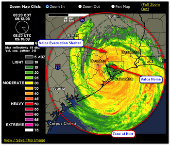
Ike radar image captured by Jim Thompson of jimthompson.org

--Claus V.

Saturday, August 15, 2009

GSD Hurricane Tracking Links – 2009

Hurricane Gordon

CC attribution: Public Domain. NASA via pingnews on flickr.

After all that “Ike Badness” last year I’m not sure I am emotionally ready for this again.  However we have really improved our processes at home and work due to “Lessons Learned” exercises and our business impact and business continuity plans are sharpened and more refined than ever before.

With that in mind, I’ve decided to go back and update my GSD Hurricane Tracking Links – 2008 post

Bookmark ‘em all!  (Or al least this post!)

Gulf Coast Watch List

So here are the hurricane links I am watching at home and work, to track the impending winds. Listed in order of my personal preference…

2008-09-07_164059

  • Stormpulse / Hurricane tracking, mapping - If you like dark-themed, special-op center techno-sites, this is the one for you. The site has a lot of information and can be customized in extra data inclusions on the chart. What really makes this one cool is that it has a “Full-Screen” mode that displays as much detail as you want for the storm-track on your monitor.  It provides a standard storm-track model, but you can select to include a bevy of additional forecast models if you want to really psych yourself out. Loaded up in Google Chrome or Chromium coupled with a nice dark Google Chrome Theme it really stands out projected on the wall of the incident command center.

  • SciGuy Blog – Chon.com’s Eric Berger - Eric has been providing outstanding details, commentary, live chat-sessions, and analysis of all science and  prognostication tropical.  Highly recommended as a filter of reason and temperance in a media-market filled with over-hype, smashing graphics, and fear-factor extremes. Besides that, you can count on Eric to provide great meteorological linkage to excellent source material like this GFS global model or this the European model.  It’s a must-follow/must-RSS feed blog for all Texas Gulf Coast residents. Period.  (see also Jeff Masters’ Wunder Blog : Weather Underground).

  • IBISEYE.com -- Your Atlantic Hurricane Season Tracking Map Source – An awesome site that mashes up tracking data on hurricanes and points of interest, along with Google Maps.  Heavy on the JavaScript but makes up for it in pure visual delight.  Easy enough even the “old-folks” can understand.  Not only are hurricanes and projected paths displayed, but also counties are added as they fall under various storm watches and warnings.  Zoom in/out for more detail.

  • Tropical Atlantic: NHC Model Data for Tropical Storms – TropicalAtlantic beta – For folks who need to have more than one storm-track model presented, this is like going from riding a pony to driving cattle from North Dakota to the Fort Worth Stockyards.  Look at the top of the page to select any current storms.  Then when the Google Map mash-up launches, you can pick from 32 “Early” models and 38 “Late” model storm track models.  Plot one or plot them all! Awesome! Additional NOAA summary of storm-track models. Also, Tropical Atlantic: Information About Atlantic Hurricanes – main-page.

  • Hurricane and Storm Tracking - Terrapin's site remains a dear favorite. It is lean and simple and allows for quick location of information without lots of graphic overkill. The storm-track plots come in two flavors, a simple historical and future projection track that is static as well as a java-based animated one. Loads fast and updated as new forecasts are posted.

  • National Hurricane Center - This website maintained by the National Weather Service is my number two choice. Lots more linkage on the sidebar for hurricane related topics and preparations. The main page has links to a number of graphics and advisories.

  • (NHC's) Atlantic Graphical Tropical Weather Outlook - A "beta" sub-page of the site listed above. This is pretty cool. Any current tropical systems are overlayed on a satellite image with an icon. Hovering over the icon pulls up a quick update view. Clicking on the update popup then takes you to the system's detailed page.

  • Moreweather.com -- Tropical Atlantic Weather Page - T-Storm Terry Faber has created a great hurricane system page here. Not only does it have lots of links to any active systems, but it also contains links to radar and satellite images, many in great details and high resolution. The hurricane tracking maps and projections are there, of course. T-Storm Terry also provides links to other sources of information as well as historical data on previous storm systems.

  • Tropical Weather : Weather Underground - This is a fantastic site that has the widest range of linkages, maps, images, models, and everything. Just about the only thing it doesn't provide is winds blown into your face through the monitor. Which is why I put this at the bottom and not the top: there is just so much information it overwhelms.

  • Oklahoma Weather Lab | Hoot - Models: GFS Model Upper-Level Wind 850mb provided us great forecast models of the high/low pressure zones and ridges leading up to Ike’s eventual landfall and really helped us understand the forces driving its path.

Local Winds

For local Houston area facts and updates, most of the local news stations have their web-sites powered up.

Even More Weather

I have found these additional links pretty cool:

Road Kill

You just don’t want to be caught off guard when one of these comes knocking at your door.

Ike_Bad

Ike radar image captured by Jim Thompson of jimthompson.org

--Claus

Saturday, October 04, 2008

Ike Badness

When Ike rolled in, it was after we had successfully evacuated from our home just north of Galveston Bay that Thursday.Ike_Bad

We still took two cars, but that was because Lavie and Alvis hadn’t waited around before heading up.  I was delayed many hours as we shut down IT operations and systems across our area and finally were released ourselves.

I unplugged all the electronics in our home, emptied the fridge as best I could, packed up our own hurricane supplies so we could add them to the communal bunker supply.  I disconnected our Shuttle desktop system and stowed it away high on a closet shelf.

Since Rita, Lavie and I had come to better terms with what we needed to take with us and what we accepted and would be left behind.  We all packed much lighter and although it was difficult, almost everything was left behind except a five-day supply of clothing, medicines, our laptops and critical file backups on multiple USB drives, and a few camping-gear items that seemed to be useful.  That was it.  While the family hamster came with us, our poor betta-fish "Mr. Tadakichi" was left behind as we hadn’t prepared how to transfer and transport him with us.  (Luckily he did just fine on his own.  Temporary accommodations will be found for the next time if he is still with us. I’m thinking a mason-jar.)

The traffic wasn’t nearly the nightmare that Rita had brought.  I was able to gas up my car and except for a few choke-points at the smaller towns that I had to pass through as I headed up to northern Liberty county where Lavie’s parents sheltered us, the drive was actually uneventful.

Friday was filled only with preparation work at the in-law’s home.  Unlike Rita we didn’t have time with it’s rapid arrival to dwell on all the local news stories. I don’t even recall turning the TV on.

That night it blew fast and furious.  At one point I thought the roof had come off and went into the attic to look.  Turns out the home was fine and strong.  When daylight broke later that Saturday, the sound we heard was several large oak tree limbs ripping off and crashing onto the well-house. No major damage but it was a horrible sound to have heard.

SciGuy blog was a great source of information during the storm’s onset and recovery. Kudos to Eric Berger.  After his balanced and metered coverage and updates, I just won’t trust anyone else. Period.  We also followed it on Stormpluse and Ibiseye.  The Oklahoma Weather Lab | Hoot - Models: GFS Model Upper-Level Wind 850mb provided us great forecast models of the high/low pressure zones and ridges leading up to Ike’s eventual landfall and really helped us understand the forces driving its path.

After Ike passed, we had no word and only images of the devastation Ike brought to the Houston and upper Texas Gulf Coast area.  It took us almost a week before we knew the condition of our home.  My brother and mom had sheltered in place at her home in the town we live in with them.  It was almost five days before he could safely venture across town and take a look at our place.  With great relief he told us that despite some blown down hibiscus plants, the total loss of one side of our fence, and some tree-limbs out back.  Today I got the fence cut into sections and stood up so the grass underneath can re-grow.  The yard is now cleaned and things are looking almost like normal again.

While we were waiting word on the condition, the biggest fear we had was storm-surge damage and flooding.  We live not very far from one of the bayous that ties into Galveston Bay. So we used the USGS.com site as well as TSARP Interactive Mapping Tool to discover that our home’s elevation is just about 17 feet above sea level and just under 1/2 miles from the bayou.  Good information to know.

In the end, the water from the storm-surge didn’t reach our home, but were it not for the brave and appreciated efforts of the few neighbors who remained behind, the plugged storm-drains might have led to our homes flooding anyway.  Water got up almost to the foundations as the many storm-grates got plugged with debris.  Every time the winds/rain abated, they would run out and rake out the debris clogging them and kept the water flowing and down…just enough…to keep everyone’s homes dry.  Amazing work and kindness or group survival.  I’m not sure but am greatly appreciative of their effort.

We did spend a number of days back home without power. It was finally restored on September 24th, and the cable (mostly) restored on the 26th.  Our Comcast digital cable (HDTV signal) still hasn’t been restored. Analogue and broadband is working just fine.  Every day I call Comcast and ask them again to send a signal refresh.  FYI, if you are a Comcast subscriber and have a Scientific American “Explorer” HDTV box, don’t believe them when they tell you to reset (reboot) the box by unplugging it.  This model actually requires a “three-finger” salute to reboot.  You push the right and left navigation buttons at the same time you are pressing the “info” button as well.

Seems that the issue we are having in our area is that the refresh signal can’t move fast-enough to update the box so it eventually times out.  Comcast assures me they are working on it.  My only question is how come I have ripping-good broadband speeds but they can’t get their digital box update signal to flow?  It’s not a big loss at the moment.  During one of the troubleshooting sessions I mentioned that their web-page says I need to call them for a billing credit due to the outage.  The tech cheerfully worked with me to figure out my approximate down-time (about two 1/2 weeks) and gave me almost a $60 credit off next-month’s bill.  That was helpful.

Finally, Google Earth has some post-Ike satellite image overlays for the Ike mess. 

The KML file you can download consists of several over-flights by NOAA capturing some (but not all) of the devastation Ike left to our region.

It was amazing to look at them.

Only thing left now to almost feel like our area is “home” again is for our local grocery store to reopen.  Apparently it had sustained some roof damage and has remained closed for remediation work.  I haven’t had the energy to go cross-town to the sister-store so we have been eating out a bit more than we should.  Besides, dragging in at 8-9PM each night I really don’t feel like cooking. I just shrug for now and figure I’m helping stimulate the economy.  I’ve still got about a case left of our MRE rations.  But that’s going to be another post.

Anyway, that’s it for now…back to the “technical” posts and enough of this boring stuff.

Special thanks to jimthompson.org for not only allowing me to use his Ike-onslaught radar graphic in this post, but to kindly pass on to me via the back-channels a number of the radar-images he captured while his broadband connection was still working as Ike pushed onshore.

Thanks Jim!

--Claus V.

Wednesday, October 01, 2008

Amazing Kindness and Hope from TinyApps Blog

Another very long day on the battlements but I can’t bear to keep this post held back any longer.

I’m the type of guy who expects little to nothing in return from others, and loves to give all I have to the betterment of those same others.  I also hold deeply to a “mono no aware” perspective towards life.

So it was with amazement that back (almost a month ago) that I got an simple email from the ever warm and thoughtful Miles at his TinyApps.Org Blog.

Miles wanted to know if I would be interested in adopting his SysInternals Video Library set.

Ummm….Heck yeah!

We have corresponded a bit over the years and share a like for portable applications and software that just makes sense without all the fluff and bloatage packed in there.  Unfortunately due to the cheapness of USB drives with ever larger space, my collection of “tiny apps” has grown quite large and it is a struggle to manage…although they are still fairly small on an individual level.  What I value most are those non-install versions of software.

Anyway.  After I picked myself up off the floor a couple of times I sent a profusely (I hope) thick-with-gratitude response back taking Miles up on the offer.

They arrived in the Valca mailbox on September the 11th.  I unboxed them and also found a beautiful card enclosed as well.  Our small household just glowed with the excitement…not just because of the joy and learning the video lessons would bring, but also for the incredible act of kindness displayed to us.

I put them on the living room mantle in a place of honor with plans to watch them during what looked to be like a rainy weekend for our area as Ike made his way onshore further down the Texas coast.

The very next day, Lavie and I had packed up the car and evacuated northward to her parents house and we watched and waited with horror as Ike eventually made a direct and devastating hit on our city.

A week later I returned home (all was mostly well) for the first time since we left, changed clothes and took a cold shower (power wasn’t restored until almost a week later) and headed into work.  Our incredible IT team has been working non-stop with no days off putting in 12-14 hour days every day, despite a flood of personal challenges and stories from every team-member.

So the DVD’s have remained safely tucked away on my bookshelf still waiting for our Ike IT recovery efforts to slow down.

I can’t wait to have the time to watch them.  TinyApps probably didn’t realize just how much of a symbol of hope and inspiration they have been to me over the past difficult weeks.

They started out as an incredible act of generosity and kindness, fresh from the paradise of Hawaii.  They became a symbol of hope as Lavie and I wondered for a week if they (and our home) survived the hurricane.  Now they have become the symbolic Champaign bottle that I go over and look at every few days and smile knowing that when our recovery efforts (personally and professionally) are over, they will be a reward of sorts (in a geeky way) for efforts well done.

Sysinternals Goodies – by the boatload!

While waiting for them to arrive and inspired by Miles, I took with renewed vigor to the Web to dig up any new Sysinternals Goodies.  Here’s what I have found since that time.

Windows Internals Book – Microsoft Technet.

Amazingly, this notice on the next installment of Windows Internals by Mark Russinovich (Windows® Internals: Including Windows Server 2008 and Windows Vista, Fifth Edition) contains five wonderful links to Vista-related Technet posts as well as a PDF version of a chapter preview in all its wonder.  Book is scheduled for a January 08 release.

The preview chapter of the new book covers Management Mechanisms including Registry, Services and WMI.: Windows Internals Chapter 4 (PDF). It’s an incredible 67 page teaser!

It’s pretty evident that this new tome on Vista is bound to immediately become Vista canon.

In fact, I was so inspired by this that I found that Amazon has the previous edition of Windows Internals on sale, so I’ve finally ordered it tonight as well.  Should be in next week at the latest!

Mark’s Blog : The Case of the Slooooow System – Mark also has posted a new detective story in which he tracks down issues on his #1 customer’s (wife) pc.  I really enjoyed this one because not only did I recognize some of the process names he was investigating, but he goes beyond the processes and shows how the underlying threads hold the real power and clues.

Coreinfo - (freeware) - This new command-line utility from Sysinternals shows the mapping between the logical processors of the system and the physical processor, NUMA node, and socket on which they reside.  Also the cache assigned to each logical processor.  Just for geeks and developers but cool all the same.

Process Monitor - (freeware) - Stop and go download this new version 2.0 release right now. Done? OK what you just got is as follows: “This major update to Process Monitor adds real-time TCP and UDP monitoring to its existing process, thread, DLL, file system and registry monitoring. You can now see the TCP and UDP activity processes performed, including the operation (e.g. connect, send, receive), local and remote IP addresses and DNS names, and operation transfer lengths. On Windows Vista, Process Monitor also collects thread stacks for network operations.”

Signing off for now…

So the delay in this big public thanks (hope TinyApps doesn’t mind) isn’t because of any lack of appreciation or manners, but only because of a lack of time, sleep, and life due to Ike and our efforts to rebuild our customers’ (and our own) lives again.  Heck.  It wasn’t until two days ago that I was finally able to reconnect our desktop system for the very first time since I left on September the 11th.  Hard to believe it has been that long ago….

From a battered but still standing Valca homestead on the Texas Gulf Coast shouting back to Hawaii…

Mahalo nui loa

--Claus

Sunday, September 21, 2008

Sleep Deprived...

The Valca clan remains well.

Grateful thanks to all who have wished us well.

I made it home last Thursday for a few hours before heading into work. The home is fine; structure good with no leaks or damage. A few window screens have disappeared along with most of the fences in the neighborhood. No tree damage. I did have to re-stake the hibiscus bushes. Our area of town out on the East side of Harris County was thrashed badly by Ike.

Like the rest of the third-world, we remain without power and may not have any until after this next Thursday.

Lavie joined me at home on Friday and then Alvis returned Saturday. We are warm but comfortable. We keep reminding ourselves that Houston was settled and its citizens thrived long before air-conditioning and refrigeration were area staples along with long-neck beers and bar-b-que. (Well, maybe not that long ago...)

Our neighbor has graciously tossed us a power-cord from her generator and we now have electric fans at night. I'm going to be sending her flowers when the lights come back on. Or maybe one of those girly "bath accoutrement" baskets in gratidue; you know the ones with the bath beads, powders, soaps and all that stuff. Then again, she's a real Texan girl so a few 6-packs of some Texas micro-brewery goodness might just do the trick. Certainly less complicated to pick out than those girly gift baskets.

I'm currently working 12-14 hour days now assisting with logistics planning and IT team deployments. We have a lot of our offices that were damaged or knocked off line. As each facility is readied for opening we have to dispatch a team to assess the technical equipment, get all the workstations up along with the network and phone systems. Long days and nights for everyone.

For the offices that cannot be opened and the staff displaced, we are scrambling to get temporary systems established at other locations. We are getting very creative. It it weren't for the lack of sleep it might actually be fun.

Fortunately we have great leadership from higher-up, and our technical team and staff is the best in the Lone Star state. So success is not a matter of "if" but only of "when."

It's mostly the lack of power, rather than time that is keeping the posts from being very frequent at the moment.

I've got some more "Chrome" bits and pieces, I bursting at the seams to share with you of an awesome pre-hurricane gift I received from Hawaii, and then there is the usual colletion of Linkfest goodies.

Hang in there GSD fans and faithful. Recovery is a process but in words of old, full of wisdom, "This too shall pass."

Cheers!

--Claus

Sunday, September 14, 2008

Woot! In the Sticks—literally—but DSL Working!

Quick update….our hands are very full at the moment.  Longer post coming later if all stays up and well.

I haven’t seen the inland storm track for Ike, but it is suspected that Ike went just to the left of us.  We certainly were on the edge or under the eye wall when it passed early Saturday morning.

Trees, limbs and other miscellaneous house-parts are scattered across the yard.

Today with the arrival of the cool front, the rains subsided and we were able to get the generator pulled outside and fired up.

Amazingly once we got a mini-fridge and some fans going, we turned attention to the hope that we could get some additional accoutrements of modern life up.

I successfully got Pop’s Dish-TV service going and now we are able to see the events and devastation around the region that is also sitting in our yard.

Because Pop has a land-line phone and DSL service, and the phone lines appeared to be functional (mostly), I re-rigged his DSL in our “command-center” bunker (his study) and, sure enough, now have broadband Intertube service as long as the lines, Central Office, and other services stay up.

We all are fine and have enjoyed spotty, but functional cell-service.

Unfortunately, until some heavy-rain waters recede and a lot of trees and lines are cleared from the roads, I’m guessing we will be staying put up here for at least another day or two.

Alas, we have not yet been able to get any word on the condition of our home.  We have been calling our home number to see if the answering-machine will pick up (a sign of power) but no response yet.  Family in the area blocks from where we live were contacted briefly, but we weren’t able to maintain a connection long enough to ask. Besides, it probably isn’t safe for anyone to be sightseeing at the moment, no matter how badly we want to know.

I’m sure we will find out more by nightfall or tomorrow morning.

For now all is well, humid, and uncomfortable, but we are gradually getting things put back in order.

Last major milestone for our temporary location is getting one of the neighbors who is the prairie-pro to help us safely hook the well-water pump up to the generator.

Then we can take showers and bottled water supply will no longer be a concern.

Cheers for now.

--Claus